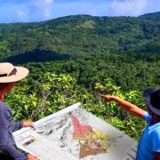
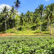
Despite continuous efforts to spread SLM practices, adoption is still alarmingly low. Successful adoption of SLM depends on a combination of factors and it is a challenge to find best SLM practices for diverse local conditions. It is, therefore, essential… Read more
Municipal Land Resources Evaluation and Integration of SAFDZ into the CLUP
Another cost-sharing and collaborative project of the BSWM-DARFO-LGU spearheaded by ALMED to generate and update soils/land resources database for reliable and precise comprehensive land use planning with emphasis on agricultural development potentials of the requesting municipality/city. To protect and implement… Read more
Land Use Assessment for Potential Agri-Environmental Development and Investment
A cost-sharing project led by ALMED in collaboration with DA-RFO and PLGU aimed to assess land uses & land limitations to cropping system development for the identification of potential areas for agricultural investment, and site specific intervention to address constraints… Read more
Various Water Resources Project
Overview BSWM through the Water Resources Management Division administers the following various water resources projects: Validation of Small Scale Irrigation Projects (SSIP) for National High Value Crops Development Program (NHVCDP) and National Organic Agriculture Program (NOAP) Geo-resistivity Survey Survey and… Read more
Strengthening and Mainstreaming the Evaluation Mechanism on Land Use Reclassification (SEMLUR)
Overview The BSWM provides technical support and services relative to land use matters, which include land use reclassification (LUR). The major basis and reference in this process are the NPAAAD-SAFDZ Maps. As prescribed in the DA Memorandum Circular No. 26… Read more
Participatory Soil Health Assessment and Productivity Improvement In Key Strategic Agricultural Production Areas...
Overview A SONA (2016) Commitment of President Rodrigo R. Duterte and one of the flagship programs is to develop color-coded agricultural guide maps which provide information on the fertility status of our soils and which crop is best suited for… Read more
Review and Updating of the Network of Protected Areas for Agriculture and Agro-Industrial...
Project Description The updated NPAAAD and SAFDZ is a Geographic Information System (GIS) database that will spatially account for the remaining suitable areas for agriculture, livestock and fishery development. This will serve as spatial basis for the preservation of the… Read more